IMAGES TAKEN NEAR TO
Fyvie, TURRIFF, AB53 8RA
Introduction
This page details the photographs taken nearby to AB53 8RA by members of the Geograph project.
The Geograph project started in 2005 with the aim of publishing, organising and preserving representative images for every square kilometre of Great Britain, Ireland and the Isle of Man.

There are currently over 7.5m images from over14,400 individuals and you can help contribute to the project by visiting https://www.geograph.org.uk
Image Map
Images are licensed for reuse under creativecommons.org/licenses/by-sa/2.0
Notes
- Clicking on the map will re-center to the selected point.
- The higher the marker number, the further away the image location is from the centre of the postcode.
Image Listing (2 Images Found)
Images are licensed for reuse under creativecommons.org/licenses/by-sa/2.0
Image
Details
Distance
1
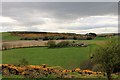
Littlehillie Farm
Littlehillie, apparently converted to housing, central and Little Clover behind amidst farmland and the whin covered hill by Fyvie Golf Course.
Image: © Andrew Wood
Taken: 23 Apr 2017
0.21 miles
2
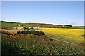
Littlehillie
Littlehillie is the farm at left of centre, almost surrounded by fields of rape. Little Colver is directly behind it, with Cloverycrook further up and to the left. Fyvie Golf Course is on the hill to the right.
Image: © Anne Burgess
Taken: 7 May 2009
0.22 miles