IMAGES TAKEN NEAR TO
Fyvie, TURRIFF, AB53 8NP
Introduction
This page details the photographs taken nearby to AB53 8NP by members of the Geograph project.
The Geograph project started in 2005 with the aim of publishing, organising and preserving representative images for every square kilometre of Great Britain, Ireland and the Isle of Man.

There are currently over 7.5m images from over14,400 individuals and you can help contribute to the project by visiting https://www.geograph.org.uk
Image Map
Images are licensed for reuse under creativecommons.org/licenses/by-sa/2.0
Notes
- Clicking on the map will re-center to the selected point.
- The higher the marker number, the further away the image location is from the centre of the postcode.
Image Listing (7 Images Found)
Images are licensed for reuse under creativecommons.org/licenses/by-sa/2.0
Image
Details
Distance
1
Moss-side, Cowhillock and Mansfield dwellings
Image: © Des Colhoun
Taken: 13 Feb 2008
0.09 miles
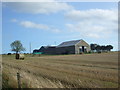
2
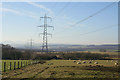
Power lines running through Stone Folds Farm
Image: © Des Colhoun
Taken: 13 Feb 2008
0.20 miles
3
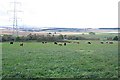
Moss of Macterry
Looking down across the fields from Callies to the boggy ground of the Moss.
Image: © Anne Burgess
Taken: 21 Sep 2007
0.20 miles
4
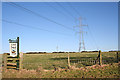
Power lines running sou'west through the Moss of Macterry
Image: © Des Colhoun
Taken: 13 Feb 2008
0.20 miles
5
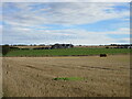
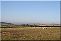
Cowiehillock from the south-west
Looking north-east across farmland to Cowiehillock.
Image: © Scott Cormie
Taken: 25 Sep 2021
0.20 miles
7
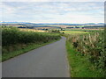
Heading down the Hill of Bodiechell
Minor road heading south-westwards downhill between Upperton and Mansefield.
Image: © Scott Cormie
Taken: 25 Sep 2021
0.24 miles