IMAGES TAKEN NEAR TO
Cuminestown, TURRIFF, AB53 8HY
Introduction
This page details the photographs taken nearby to AB53 8HY by members of the Geograph project.
The Geograph project started in 2005 with the aim of publishing, organising and preserving representative images for every square kilometre of Great Britain, Ireland and the Isle of Man.

There are currently over 7.5m images from over14,400 individuals and you can help contribute to the project by visiting https://www.geograph.org.uk
Image Map
Images are licensed for reuse under creativecommons.org/licenses/by-sa/2.0
Notes
- Clicking on the map will re-center to the selected point.
- The higher the marker number, the further away the image location is from the centre of the postcode.
Image Listing (4 Images Found)
Images are licensed for reuse under creativecommons.org/licenses/by-sa/2.0
Image
Details
Distance
1
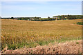
Looking towards Stonehouse
I think Stonehouse is the red sandstone house partly obscured by trees at right. On the left, also mostly obscured, is Rosebrae. It almost goes without saying that the crop is barley.
Image: © Anne Burgess
Taken: 22 Jul 2014
0.17 miles
2
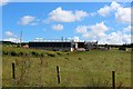
Meadowbank Farm
Meadowbank with animals grazing appropriately enough and Wagglehill woodland behind.
Image: © Andrew Wood
Taken: 21 Jul 2020
0.17 miles
3
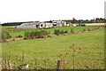
Meadowbank
A big farm above the road in the Howe of Teuchar.
Image: © Anne Burgess
Taken: 21 Sep 2007
0.18 miles
4
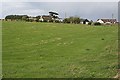
Quarryhead of Teuchar
There seem to be several new houses here at Quarryhead.
Image: © Anne Burgess
Taken: 21 Sep 2007
0.22 miles