IMAGES TAKEN NEAR TO
TURRIFF, AB53 8HW
Introduction
This page details the photographs taken nearby to AB53 8HW by members of the Geograph project.
The Geograph project started in 2005 with the aim of publishing, organising and preserving representative images for every square kilometre of Great Britain, Ireland and the Isle of Man.

There are currently over 7.5m images from over14,400 individuals and you can help contribute to the project by visiting https://www.geograph.org.uk
Image Map
Images are licensed for reuse under creativecommons.org/licenses/by-sa/2.0
Notes
- Clicking on the map will re-center to the selected point.
- The higher the marker number, the further away the image location is from the centre of the postcode.
Image Listing (6 Images Found)
Images are licensed for reuse under creativecommons.org/licenses/by-sa/2.0
Image
Details
Distance
1
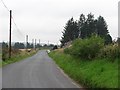
B9170
The road from Turriff to Cuminestown passes some cottages in arable farming country.
Image: © Richard Webb
Taken: 4 Aug 2011
0.10 miles
2
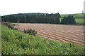
Mains of Idoch
The flat floor of the valley here suggests that it may at one time have been a loch.
Image: © Anne Burgess
Taken: 13 Sep 2007
0.12 miles
3
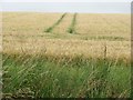
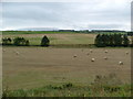
Barley, Woodhead of Delgaty
Ripening barley above the B9170.
Image: © Richard Webb
Taken: 4 Aug 2011
0.12 miles
6
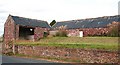
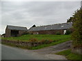
Mains of Idoch
Red sandstone farm buildings by the road at Mains of Idoch.
Image: © Anne Burgess
Taken: 13 Sep 2007
0.24 miles