IMAGES TAKEN NEAR TO
TURRIFF, AB53 8HN
Introduction
This page details the photographs taken nearby to AB53 8HN by members of the Geograph project.
The Geograph project started in 2005 with the aim of publishing, organising and preserving representative images for every square kilometre of Great Britain, Ireland and the Isle of Man.

There are currently over 7.5m images from over14,400 individuals and you can help contribute to the project by visiting https://www.geograph.org.uk
Image Map
Images are licensed for reuse under creativecommons.org/licenses/by-sa/2.0
Notes
- Clicking on the map will re-center to the selected point.
- The higher the marker number, the further away the image location is from the centre of the postcode.
Image Listing (6 Images Found)
Images are licensed for reuse under creativecommons.org/licenses/by-sa/2.0
Image
Details
Distance
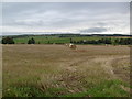
1
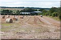
Ardinn
A harvested field at Ardinn. The farm buildings are just inside the next square.
Image: © Anne Burgess
Taken: 13 Sep 2007
0.10 miles
2
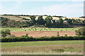
Little Ardinn
The farm buildings at Little Ardin are sensibly sited above the floodplain of the Idoch Water.
Image: © Anne Burgess
Taken: 22 Jul 2014
0.18 miles
3
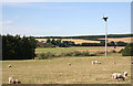
Little Ardinn
Looking across the flat haugh land by the Idoch Water to Little Ardinn on the brae above.
Image: © Anne Burgess
Taken: 22 Jul 2014
0.19 miles
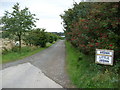
6
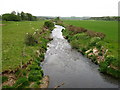
Idoch Water
View of the river from the B9170 road bridge.
Image: © don cload
Taken: 24 May 2011
0.22 miles