IMAGES TAKEN NEAR TO
TURRIFF, AB53 8HG
Introduction
This page details the photographs taken nearby to AB53 8HG by members of the Geograph project.
The Geograph project started in 2005 with the aim of publishing, organising and preserving representative images for every square kilometre of Great Britain, Ireland and the Isle of Man.

There are currently over 7.5m images from over14,400 individuals and you can help contribute to the project by visiting https://www.geograph.org.uk
Image Map
Images are licensed for reuse under creativecommons.org/licenses/by-sa/2.0
Notes
- Clicking on the map will re-center to the selected point.
- The higher the marker number, the further away the image location is from the centre of the postcode.
Image Listing (5 Images Found)
Images are licensed for reuse under creativecommons.org/licenses/by-sa/2.0
Image
Details
Distance
1
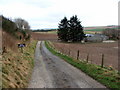
South Camalynes Farm
Taken from the old road along the edge of the Braes of Slack o'Causeway looking down towards the farm access road and farm itself.
Image: © Alison Mack
Taken: 22 Mar 2009
0.01 miles
2
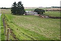
South Camalynes
Most of the land here seems to be in use for grazing cattle.
Image: © Anne Burgess
Taken: 21 Sep 2007
0.03 miles
3
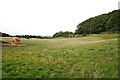
South Camalynes
Pasture land north of the farm buildings. The road in is above the field, on the right.
Image: © Anne Burgess
Taken: 21 Sep 2007
0.13 miles
4
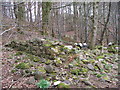
Ruined Building on Braes of Slack o' Causeway
Unfortunately, although out of the way, this ruined building has been used over many years, it would seem, for dumping old pots and pans and other household rubbish!
Image: © Alison Mack
Taken: 22 Mar 2009
0.15 miles
5
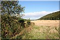
Braes of Slack o'Causeway
The braes are clothed in deciduous woodland. In the distance is the farm of South Camalynes, which is just out of square.
Image: © Anne Burgess
Taken: 21 Sep 2007
0.23 miles