IMAGES TAKEN NEAR TO
TURRIFF, AB53 8HE
Introduction
This page details the photographs taken nearby to AB53 8HE by members of the Geograph project.
The Geograph project started in 2005 with the aim of publishing, organising and preserving representative images for every square kilometre of Great Britain, Ireland and the Isle of Man.

There are currently over 7.5m images from over14,400 individuals and you can help contribute to the project by visiting https://www.geograph.org.uk
Image Map
Images are licensed for reuse under creativecommons.org/licenses/by-sa/2.0
Notes
- Clicking on the map will re-center to the selected point.
- The higher the marker number, the further away the image location is from the centre of the postcode.
Image Listing (6 Images Found)
Images are licensed for reuse under creativecommons.org/licenses/by-sa/2.0
Image
Details
Distance
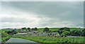
1
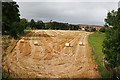
Towie Bridge
The bridge which spanned the long-vanished railway line to Turriff provides an elevated viewpoint over this field at Towie.
Image: © Anne Burgess
Taken: 21 Sep 2007
0.13 miles
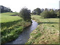
2
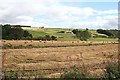
Steinman Hill from Towie
Looking across the haugh land by the River Ytahn to the farms on Steinman Hill. North Camalynes is in the centre, and Loop on the skyline to the left.
Image: © Anne Burgess
Taken: 21 Sep 2007
0.21 miles
4
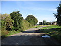
Northward on A947 road to site of Auchterless station at Mains of Towie
The station was on the ex-GNSR branch from Inveramsay - Macduff off the Aberdeen - Elgin main line. The station here and line were closed to passengers from 1/10/51; the line was closed to goods Turriff - Macduff from 1/8/61, Inveramsay - Turriff (through Auchterless) from 3/1/66.
Image: © Ben Brooksbank
Taken: 4 Jul 1997
0.23 miles