IMAGES TAKEN NEAR TO
TURRIFF, AB53 8HA
Introduction
This page details the photographs taken nearby to AB53 8HA by members of the Geograph project.
The Geograph project started in 2005 with the aim of publishing, organising and preserving representative images for every square kilometre of Great Britain, Ireland and the Isle of Man.

There are currently over 7.5m images from over14,400 individuals and you can help contribute to the project by visiting https://www.geograph.org.uk
Image Map
Images are licensed for reuse under creativecommons.org/licenses/by-sa/2.0
Notes
- Clicking on the map will re-center to the selected point.
- The higher the marker number, the further away the image location is from the centre of the postcode.
Image Listing (5 Images Found)
Images are licensed for reuse under creativecommons.org/licenses/by-sa/2.0
Image
Details
Distance
1
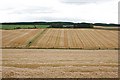
Lendrum
Looking across the hollow from Backhill of Gourdas towards Lendrum, above the striped effect of recently harvested fields.
Image: © Anne Burgess
Taken: 21 Sep 2007
0.04 miles
2
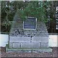
Robert Paterson Monument
Robert Paterson farmed here at Lendrum, and was the farmer involved in the famous incident of Image The monument stands just outside Lendrum, in the shade of some trees that could do with being trimmed a bit. It has three polished granite faces. The east-facing one reads, "In memory of Robert Paterson JP 1868-1934, auctioneer, progressive farmer and timber merchant. Farmed Lendrum 1903-1934. Public benefactor in many spheres. Erected by the Paterson family 1971." Image] Image
Image: © Anne Burgess
Taken: 27 Feb 2015
0.06 miles
3
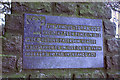
South Face of Robert Paterson Monument
See Image
Image: © Anne Burgess
Taken: 27 Feb 2015
0.06 miles
4
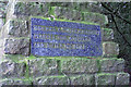
North Face of Robert Paterson Monument
See Image
Image: © Anne Burgess
Taken: 27 Feb 2015
0.06 miles
5
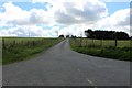
Lendrum Road
A view up an unclassified side road to Lendrum Farm just visible top right.
Image: © Andrew Wood
Taken: 21 Jul 2020
0.11 miles