IMAGES TAKEN NEAR TO
TURRIFF, AB53 8EU
Introduction
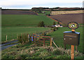
This page details the photographs taken nearby to AB53 8EU by members of the Geograph project.
The Geograph project started in 2005 with the aim of publishing, organising and preserving representative images for every square kilometre of Great Britain, Ireland and the Isle of Man.

There are currently over 7.5m images from over14,400 individuals and you can help contribute to the project by visiting https://www.geograph.org.uk
Image Map
Images are licensed for reuse under creativecommons.org/licenses/by-sa/2.0
Notes
- Clicking on the map will re-center to the selected point.
- The higher the marker number, the further away the image location is from the centre of the postcode.
Image Listing (2 Images Found)
Images are licensed for reuse under creativecommons.org/licenses/by-sa/2.0
Image
Details
Distance
2
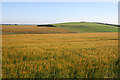
Acres and Acres of Barley
All the orange-coloured cereal crops are barley, which is by a very large margin the commonest crop grown in this area. The green is pasture on Lendrum Hill.
Image: © Anne Burgess
Taken: 22 Jul 2014
0.24 miles