IMAGES TAKEN NEAR TO
Auchterless, TURRIFF, AB53 8DJ
Introduction
This page details the photographs taken nearby to AB53 8DJ by members of the Geograph project.
The Geograph project started in 2005 with the aim of publishing, organising and preserving representative images for every square kilometre of Great Britain, Ireland and the Isle of Man.

There are currently over 7.5m images from over14,400 individuals and you can help contribute to the project by visiting https://www.geograph.org.uk
Image Map
Images are licensed for reuse under creativecommons.org/licenses/by-sa/2.0
Notes
- Clicking on the map will re-center to the selected point.
- The higher the marker number, the further away the image location is from the centre of the postcode.
Image Listing (5 Images Found)
Images are licensed for reuse under creativecommons.org/licenses/by-sa/2.0
Image
Details
Distance
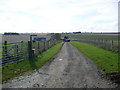
1
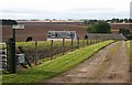
Rapplaburn
A mixed arable and livestock farm. The burn is in the dip beyond the farm.
Image: © Anne Burgess
Taken: 21 Sep 2007
0.01 miles
3
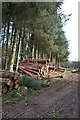
Rappla Wood
Though much of the wood is deciduous, this part is a conifer plantation, evidently in course of being harvested.
Image: © Anne Burgess
Taken: 21 Sep 2007
0.11 miles
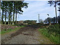
5
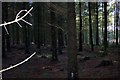
Rappla Woods Aberdeenshire 2006
Inside the woods
Image: © stephen samson
Taken: 22 Oct 2006
0.23 miles