IMAGES TAKEN NEAR TO
Auchterless, TURRIFF, AB53 8DH
Introduction
This page details the photographs taken nearby to AB53 8DH by members of the Geograph project.
The Geograph project started in 2005 with the aim of publishing, organising and preserving representative images for every square kilometre of Great Britain, Ireland and the Isle of Man.

There are currently over 7.5m images from over14,400 individuals and you can help contribute to the project by visiting https://www.geograph.org.uk
Image Map
Images are licensed for reuse under creativecommons.org/licenses/by-sa/2.0
Notes
- Clicking on the map will re-center to the selected point.
- The higher the marker number, the further away the image location is from the centre of the postcode.
Image Listing (3 Images Found)
Images are licensed for reuse under creativecommons.org/licenses/by-sa/2.0
Image
Details
Distance
1
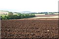
Howe of Auchterless
The River Ythan flows among the trees on the left of this view. The kirk spire at Kirktown of Auchterless can be seen above the trees in the distance.
Image: © Anne Burgess
Taken: 21 Sep 2007
0.15 miles
2
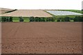
Howe of Auchterless
The ploughed land is in square, but the harvested field and the one with netting to protect the crop are in the next square.
Image: © Anne Burgess
Taken: 13 Sep 2007
0.20 miles
3
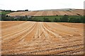
Chapel of Seggat
The large farm on the left is Chapel of Seggat. This is in the part of the valley of the River Ythan which is known as the Howe of Auchterless. A howe is a valley or low-lying tract of ground.
Image: © Anne Burgess
Taken: 13 Sep 2007
0.24 miles