IMAGES TAKEN NEAR TO
Auchterless, TURRIFF, AB53 8BB
Introduction
This page details the photographs taken nearby to AB53 8BB by members of the Geograph project.
The Geograph project started in 2005 with the aim of publishing, organising and preserving representative images for every square kilometre of Great Britain, Ireland and the Isle of Man.

There are currently over 7.5m images from over14,400 individuals and you can help contribute to the project by visiting https://www.geograph.org.uk
Image Map
Images are licensed for reuse under creativecommons.org/licenses/by-sa/2.0
Notes
- Clicking on the map will re-center to the selected point.
- The higher the marker number, the further away the image location is from the centre of the postcode.
Image Listing (5 Images Found)
Images are licensed for reuse under creativecommons.org/licenses/by-sa/2.0
Image
Details
Distance
1
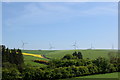
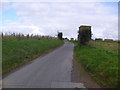
Farmland with wind turbines
View from Auchterless of the minor road to Fyvie climbing out of the valley with the wind farm on Gordonstown Hill in the distance.
Image: © Bill Harrison
Taken: 26 May 2018
0.09 miles
3
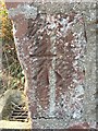
OS Cut Mark: Kirkton of Auchterless, Hall
Ordnance Survey - Cut Mark: Kirkton of Auchterless, Hall
Image: © thejackrustles
Taken: 25 Aug 2018
0.18 miles
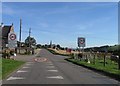
4

Minor road near Kirkton of Auchterless
Image: © Steven Brown
Taken: 15 Feb 2014
0.23 miles