IMAGES TAKEN NEAR TO
AB53 7QP
Introduction
This page details the photographs taken nearby to AB53 7QP by members of the Geograph project.
The Geograph project started in 2005 with the aim of publishing, organising and preserving representative images for every square kilometre of Great Britain, Ireland and the Isle of Man.

There are currently over 7.5m images from over14,400 individuals and you can help contribute to the project by visiting https://www.geograph.org.uk
Image Map
Images are licensed for reuse under creativecommons.org/licenses/by-sa/2.0
Notes
- Clicking on the map will re-center to the selected point.
- The higher the marker number, the further away the image location is from the centre of the postcode.
Image Listing (5 Images Found)
Images are licensed for reuse under creativecommons.org/licenses/by-sa/2.0
Image
Details
Distance
2
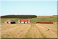
Ruined Croft
A long ruined and anonymous croft by Overbrae.
Image: © Andrew Wood
Taken: 21 Jul 2020
0.22 miles
4
Derelict cottage to the east of Backhill Croft
Image: © Des Colhoun
Taken: 6 Feb 2008
0.22 miles
5
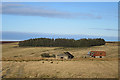
Ruins of a Croft
This croft is marked but not named on the first edition of the Ordnance Survey map. It is next to Backhill of Overbrae.
Image: © Anne Burgess
Taken: 5 Feb 2018
0.22 miles