IMAGES TAKEN NEAR TO
AB53 7PY
Introduction
This page details the photographs taken nearby to AB53 7PY by members of the Geograph project.
The Geograph project started in 2005 with the aim of publishing, organising and preserving representative images for every square kilometre of Great Britain, Ireland and the Isle of Man.

There are currently over 7.5m images from over14,400 individuals and you can help contribute to the project by visiting https://www.geograph.org.uk
Image Map
Images are licensed for reuse under creativecommons.org/licenses/by-sa/2.0
Notes
- Clicking on the map will re-center to the selected point.
- The higher the marker number, the further away the image location is from the centre of the postcode.
Image Listing (4 Images Found)
Images are licensed for reuse under creativecommons.org/licenses/by-sa/2.0
Image
Details
Distance
1
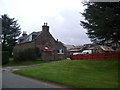
Smiddy Carriage
An interesting renovation on what appears to be a GNSR railway carriage at Cauldwells Smithy. The road at the junction is the B9105.
Image: © Andrew Wood
Taken: 21 Jul 2020
0.18 miles
2
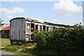
Old Railway Carriage
At Aden Country Park there is (or used to be - must go and check) a show farm which is worked in traditional style. According to this, one of the features of many a farm in north-east Scotland was an old railway carriage, transported there somehow or other and being used as a shed or other outbuilding. This is just such a carriage, though it doesn't look to be in very good condition.
Image: © Anne Burgess
Taken: 22 Jul 2014
0.18 miles
3
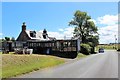
Cauldwells Farm
The roadside farm of Cauldwells with a view south.
Image: © Andrew Wood
Taken: 21 Jul 2020
0.22 miles