IMAGES TAKEN NEAR TO
New Deer, TURRIFF, AB53 6YX
Introduction
This page details the photographs taken nearby to AB53 6YX by members of the Geograph project.
The Geograph project started in 2005 with the aim of publishing, organising and preserving representative images for every square kilometre of Great Britain, Ireland and the Isle of Man.

There are currently over 7.5m images from over14,400 individuals and you can help contribute to the project by visiting https://www.geograph.org.uk
Image Map
Images are licensed for reuse under creativecommons.org/licenses/by-sa/2.0
Notes
- Clicking on the map will re-center to the selected point.
- The higher the marker number, the further away the image location is from the centre of the postcode.
Image Listing (2 Images Found)
Images are licensed for reuse under creativecommons.org/licenses/by-sa/2.0
Image
Details
Distance
1
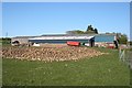
A Heap o' Neeps
Neeps left over from last year's harvest are stored at Whitebog Farm.
Image: © Anne Burgess
Taken: 14 May 2009
0.03 miles
2
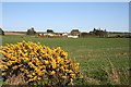
Greenbrae
A typical mixed farm. The lop-sided gable of the farm house suggests that it has been extended at some time.
Image: © Anne Burgess
Taken: 14 May 2009
0.19 miles