IMAGES TAKEN NEAR TO
New Deer, TURRIFF, AB53 6YU
Introduction
This page details the photographs taken nearby to AB53 6YU by members of the Geograph project.
The Geograph project started in 2005 with the aim of publishing, organising and preserving representative images for every square kilometre of Great Britain, Ireland and the Isle of Man.

There are currently over 7.5m images from over14,400 individuals and you can help contribute to the project by visiting https://www.geograph.org.uk
Image Map
Images are licensed for reuse under creativecommons.org/licenses/by-sa/2.0
Notes
- Clicking on the map will re-center to the selected point.
- The higher the marker number, the further away the image location is from the centre of the postcode.
Image Listing (6 Images Found)
Images are licensed for reuse under creativecommons.org/licenses/by-sa/2.0
Image
Details
Distance
3
NEW
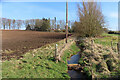
Burn at Allathan
The burn isn't named on the maps, but it flows through the grounds of Allathan House, which is partly visible among the trees in the distance.
Image: © Anne Burgess
Taken: 20 Mar 2025
0.08 miles
4
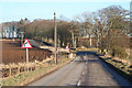
Looking eastwards towards Dam Brig on the B9170
Image: © Des Colhoun
Taken: 14 Feb 2008
0.22 miles
6
NEW
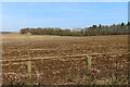
Fields near Allathan
The line of trees marks the drive to Royston, which is in the next grid square.
Image: © Anne Burgess
Taken: 20 Mar 2025
0.25 miles