IMAGES TAKEN NEAR TO
New Deer, TURRIFF, AB53 6YE
Introduction
This page details the photographs taken nearby to AB53 6YE by members of the Geograph project.
The Geograph project started in 2005 with the aim of publishing, organising and preserving representative images for every square kilometre of Great Britain, Ireland and the Isle of Man.

There are currently over 7.5m images from over14,400 individuals and you can help contribute to the project by visiting https://www.geograph.org.uk
Image Map
Images are licensed for reuse under creativecommons.org/licenses/by-sa/2.0
Notes
- Clicking on the map will re-center to the selected point.
- The higher the marker number, the further away the image location is from the centre of the postcode.
Image Listing (4 Images Found)
Images are licensed for reuse under creativecommons.org/licenses/by-sa/2.0
Image
Details
Distance
1
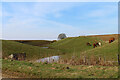
NEW
Little Slacks
This channel has the look of a glacial meltwater channel formed as the glaciers melted at the end of the last Ice Age.
Image: © Anne Burgess
Taken: 20 Mar 2025
0.07 miles
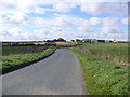
3
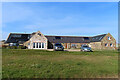
NEW
Converted Steading
The farm steading at Slacks of Cairnbanno has been converted into housing.
Image: © Anne Burgess
Taken: 20 Mar 2025
0.15 miles
4
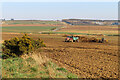
NEW
Muck Spreading
Farm machinery spreading muck from a byre to fertilise the soil. The large buildings at extreme right are part of Image
Image: © Anne Burgess
Taken: 20 Mar 2025
0.15 miles