IMAGES TAKEN NEAR TO
New Deer, TURRIFF, AB53 6YB
Introduction
This page details the photographs taken nearby to AB53 6YB by members of the Geograph project.
The Geograph project started in 2005 with the aim of publishing, organising and preserving representative images for every square kilometre of Great Britain, Ireland and the Isle of Man.

There are currently over 7.5m images from over14,400 individuals and you can help contribute to the project by visiting https://www.geograph.org.uk
Image Map
Images are licensed for reuse under creativecommons.org/licenses/by-sa/2.0
Notes
- Clicking on the map will re-center to the selected point.
- The higher the marker number, the further away the image location is from the centre of the postcode.
Image Listing (8 Images Found)
Images are licensed for reuse under creativecommons.org/licenses/by-sa/2.0
Image
Details
Distance
1
NEW
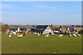
Netherton of Greens
A small cluster of new houses has been developed around the old farm house.
Image: © Anne Burgess
Taken: 20 Mar 2025
0.02 miles
2
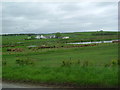
NEW
Netherlea
Netherlea is a new house surrounded by farmland.
Image: © Anne Burgess
Taken: 20 Mar 2025
0.11 miles
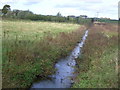
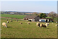
7
Drainage ditch east of the Mill of Greens
Image: © Des Colhoun
Taken: 13 Feb 2008
0.24 miles
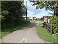
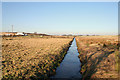
8
Southbound drainage ditch near Mill of Greens
Image: © Des Colhoun
Taken: 13 Feb 2008
0.24 miles