IMAGES TAKEN NEAR TO
New Deer, TURRIFF, AB53 6UE
Introduction
This page details the photographs taken nearby to AB53 6UE by members of the Geograph project.
The Geograph project started in 2005 with the aim of publishing, organising and preserving representative images for every square kilometre of Great Britain, Ireland and the Isle of Man.

There are currently over 7.5m images from over14,400 individuals and you can help contribute to the project by visiting https://www.geograph.org.uk
Image Map
Images are licensed for reuse under creativecommons.org/licenses/by-sa/2.0
Notes
- Clicking on the map will re-center to the selected point.
- The higher the marker number, the further away the image location is from the centre of the postcode.
Image Listing (2 Images Found)
Images are licensed for reuse under creativecommons.org/licenses/by-sa/2.0
Image
Details
Distance
2
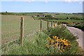
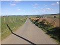
Oldwhat Mains
The Mains is in the distance, close by the side of the unclassified road. The fence on the left has netting to keep sheep in, and barbed wire to keep cattle in. Sheep will readily wriggle through between strands of wire, even barbed, and frisky young cattle may try to jump over if the top wire is not high enough to make them think again. Not that any fencing is needed this year, because the field has been sown with a spring cereal.
Image: © Anne Burgess
Taken: 11 May 2009
0.25 miles