IMAGES TAKEN NEAR TO
The Brae, TURRIFF, AB53 6TG
Introduction
This page details the photographs taken nearby to The Brae, AB53 6TG by members of the Geograph project.
The Geograph project started in 2005 with the aim of publishing, organising and preserving representative images for every square kilometre of Great Britain, Ireland and the Isle of Man.

There are currently over 7.5m images from over14,400 individuals and you can help contribute to the project by visiting https://www.geograph.org.uk
Image Map
Images are licensed for reuse under creativecommons.org/licenses/by-sa/2.0
Notes
- Clicking on the map will re-center to the selected point.
- The higher the marker number, the further away the image location is from the centre of the postcode.
Image Listing (35 Images Found)
Images are licensed for reuse under creativecommons.org/licenses/by-sa/2.0
Image
Details
Distance
2

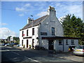
NEW
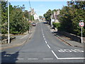
Earl of Aberdeen Arms
The pub stands on East Auchreddie Road beside the crossroads from which The Brae climbs to the village centre.
Image: © Anne Burgess
Taken: 20 Mar 2025
0.04 miles
3
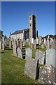
St Kane's Parish Kirk
The kirk was originally a simple rectangle, built in 1838 and replacing an older kirk dating from 1622. The tower was added in 1865. The A981 passes between the kirk and the kirkyard.
Image: © Anne Burgess
Taken: 14 May 2009
0.04 miles
5
St Kane's Church, New Deer
Image: © Adrian and Janet Quantock
Taken: 6 Jun 2006
0.05 miles
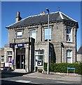
6
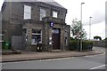
Royal Bank of Scotland, New Deer branch
Formerly the Clydesdale Bank, but closed in that bank's savage purge of its rural branches ca. 2005. After negotiations said to involve Alex Salmond and Fred Goodwin, it reopened as an RBS outlet.
Image: © Bill Harrison
Taken: 2 Apr 2016
0.05 miles
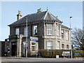
9
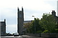
Royal Bank of Scotland
New Deer still has many of the services that other villages have lost, perhaps because of its distance from any larger towns. Noting its position and the angled south elevation, I wonder whether this is the site of a former toll house?
Image: © Anne Burgess
Taken: 14 May 2009
0.06 miles
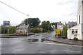
10
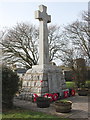
New Deer war memorial
Located in the so-called 'God's acre' opposite the parish kirk.
Image: © Bill Harrison
Taken: 2 Apr 2016
0.06 miles