IMAGES TAKEN NEAR TO
Cuminestown, TURRIFF, AB53 5YU
Introduction
This page details the photographs taken nearby to AB53 5YU by members of the Geograph project.
The Geograph project started in 2005 with the aim of publishing, organising and preserving representative images for every square kilometre of Great Britain, Ireland and the Isle of Man.

There are currently over 7.5m images from over14,400 individuals and you can help contribute to the project by visiting https://www.geograph.org.uk
Image Map
Images are licensed for reuse under creativecommons.org/licenses/by-sa/2.0
Notes
- Clicking on the map will re-center to the selected point.
- The higher the marker number, the further away the image location is from the centre of the postcode.
Image Listing (6 Images Found)
Images are licensed for reuse under creativecommons.org/licenses/by-sa/2.0
Image
Details
Distance
2
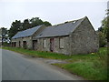
Steading, Mid Balthangie
Old stone farm buildings.
Image: © Richard Webb
Taken: 4 Aug 2011
0.02 miles
3
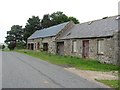
Old railway wagon, Mid Balthangie
One of thousands of decommissioned freight cars from the 1960s when British Rail all but gave up moving stuff. Many found their way into a new career as agricultural buildings.
Image: © Richard Webb
Taken: 4 Aug 2011
0.04 miles
4
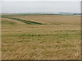
Balthangie barley
Spring barley crop at Mid Balthangie.
Image: © Richard Webb
Taken: 4 Aug 2011
0.07 miles
5
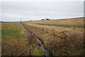
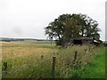
Drainage of Balthangie Mains looking northwards
Image: © Des Colhoun
Taken: 10 Feb 2008
0.24 miles
6
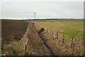
Southbound drainage ditch of Balthangie
Image: © Des Colhoun
Taken: 10 Feb 2008
0.25 miles