IMAGES TAKEN NEAR TO
Cuminestown, TURRIFF, AB53 5XX
Introduction
This page details the photographs taken nearby to AB53 5XX by members of the Geograph project.
The Geograph project started in 2005 with the aim of publishing, organising and preserving representative images for every square kilometre of Great Britain, Ireland and the Isle of Man.

There are currently over 7.5m images from over14,400 individuals and you can help contribute to the project by visiting https://www.geograph.org.uk
Image Map
Images are licensed for reuse under creativecommons.org/licenses/by-sa/2.0
Notes
- Clicking on the map will re-center to the selected point.
- The higher the marker number, the further away the image location is from the centre of the postcode.
Image Listing (3 Images Found)
Images are licensed for reuse under creativecommons.org/licenses/by-sa/2.0
Image
Details
Distance
1

Whitestones
A traditional stone-built farm house with an open view to the south-west.
Image: © Anne Burgess
Taken: 11 May 2009
0.01 miles
2

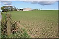
Road between West and East Whitestones
Looking south-eastward towards Mid Whitestones.
Image: © Peter Wood
Taken: 21 Nov 2019
0.14 miles
3
East Whitestones
The farm house at East Whitestones is dwarfed by the unusually large, relatively modern barn.
Image: © Anne Burgess
Taken: 11 May 2009
0.15 miles