IMAGES TAKEN NEAR TO
New Byth, TURRIFF, AB53 5XS
Introduction
This page details the photographs taken nearby to AB53 5XS by members of the Geograph project.
The Geograph project started in 2005 with the aim of publishing, organising and preserving representative images for every square kilometre of Great Britain, Ireland and the Isle of Man.

There are currently over 7.5m images from over14,400 individuals and you can help contribute to the project by visiting https://www.geograph.org.uk
Image Map
Images are licensed for reuse under creativecommons.org/licenses/by-sa/2.0
Notes
- Clicking on the map will re-center to the selected point.
- The higher the marker number, the further away the image location is from the centre of the postcode.
Image Listing (12 Images Found)
Images are licensed for reuse under creativecommons.org/licenses/by-sa/2.0
Image
Details
Distance
1
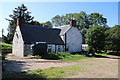
Upper Auchnagorth
A solid traditional stone farm house, well screened by trees for the worst of the weather.
Image: © Anne Burgess
Taken: 26 Aug 2019
0.00 miles
2
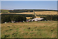
Upper Auchnagorth
The farm steading and a selection of machinery and cattle at Upper Auchnagorth. The house is hidden by the trees.
Image: © Anne Burgess
Taken: 26 Aug 2019
0.02 miles
3
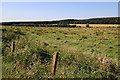
Upper Auchnagorth
Fields beside the track to Upper Auchnagorth.
Image: © Anne Burgess
Taken: 26 Aug 2019
0.07 miles
4
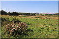
Upper Auchnagorth
Farmland beside the track to Upper Auchnagorth. That's been a fine clump of Spear Thistles in the left foreground.
Image: © Anne Burgess
Taken: 26 Aug 2019
0.18 miles
5
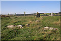
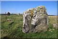
Upper Auchnagorth Stone Circle (6)
There are ten stones in this circle, three of which are still erect. These are the two smaller stones, with a fallen stone in front. See https://canmore.org.uk/site/19926/upper-auchnagorth for more details. Image]
Image: © Anne Burgess
Taken: 26 Aug 2019
0.18 miles
6
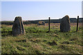
Upper Auchnagorth Stone Circle (4)
There are ten stones in this circle, three of which are still erect. These are some of the fallen stones, with two of the erect ones in the background. See https://canmore.org.uk/site/19926/upper-auchnagorth for more details. Image]
Image: © Anne Burgess
Taken: 26 Aug 2019
0.19 miles
7
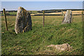
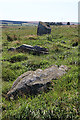
Upper Auchnagorth Stone Circle (1)
There are ten stones in this circle, three of which are still erect. A fence runs close to two of these, which rather spoils the effect. See https://canmore.org.uk/site/19926/upper-auchnagorth for more details. Image]
Image: © Anne Burgess
Taken: 26 Aug 2019
0.19 miles
8
Upper Auchnagorth Stone Circle (2)
There are ten stones in this circle, three of which are still erect. In this view the largest stone is closest to the camera. See https://canmore.org.uk/site/19926/upper-auchnagorth for more details. Image]
Image: © Anne Burgess
Taken: 26 Aug 2019
0.19 miles
9
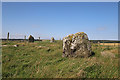
Upper Auchnagorth Stone Circle (3)
There are ten stones in this circle, three of which are still erect. This is largest stone, which fortunately is large enough to hide a rather unappealing concrete building in the background! See https://canmore.org.uk/site/19926/upper-auchnagorth for more details. Image]
Image: © Anne Burgess
Taken: 26 Aug 2019
0.19 miles
10
Upper Auchnagorth Stone Circle (7)
There are ten stones in this circle, three of which are still erect.See https://canmore.org.uk/site/19926/upper-auchnagorth for more details. These fallen stones make up part of the circumference of the circel. Image]
Image: © Anne Burgess
Taken: 26 Aug 2019
0.19 miles