IMAGES TAKEN NEAR TO
New Byth, TURRIFF, AB53 5UY
Introduction
This page details the photographs taken nearby to AB53 5UY by members of the Geograph project.
The Geograph project started in 2005 with the aim of publishing, organising and preserving representative images for every square kilometre of Great Britain, Ireland and the Isle of Man.

There are currently over 7.5m images from over14,400 individuals and you can help contribute to the project by visiting https://www.geograph.org.uk
Image Map
Images are licensed for reuse under creativecommons.org/licenses/by-sa/2.0
Notes
- Clicking on the map will re-center to the selected point.
- The higher the marker number, the further away the image location is from the centre of the postcode.
Image Listing (6 Images Found)
Images are licensed for reuse under creativecommons.org/licenses/by-sa/2.0
Image
Details
Distance
1
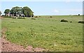
Newton of Bogenlea
Seen from Bogenlea. There is a road, not shown on the 1:50,000 map, linking the two farms, but it is on the 1:25,000 map.
Image: © Anne Burgess
Taken: 2 Jul 2009
0.01 miles
3
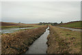
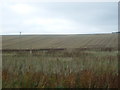
Burn of Monquhitter by Meikle Blackhills Farm
The drainage ditches and burns in this area are obviously well maintained and synonymous with the general high regard for the skill and labour of the local farming communities.
Image: © Des Colhoun
Taken: 10 Feb 2008
0.18 miles
4
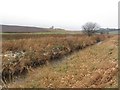
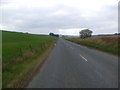
Burn of Monquhitter
The burn has been straightened out and is used to drain the valley bottom to form good arable land.
Image: © Richard Webb
Taken: 21 Dec 2011
0.20 miles