IMAGES TAKEN NEAR TO
TURRIFF, AB53 5UX
Introduction
This page details the photographs taken nearby to AB53 5UX by members of the Geograph project.
The Geograph project started in 2005 with the aim of publishing, organising and preserving representative images for every square kilometre of Great Britain, Ireland and the Isle of Man.

There are currently over 7.5m images from over14,400 individuals and you can help contribute to the project by visiting https://www.geograph.org.uk
Image Map
Images are licensed for reuse under creativecommons.org/licenses/by-sa/2.0
Notes
- Clicking on the map will re-center to the selected point.
- The higher the marker number, the further away the image location is from the centre of the postcode.
Image Listing (4 Images Found)
Images are licensed for reuse under creativecommons.org/licenses/by-sa/2.0
Image
Details
Distance
2
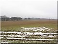
Stubble, Millfield
A raw morning as the frost lifts from arable land between Cuminestown and New Byth.
Image: © Richard Webb
Taken: 21 Dec 2011
0.15 miles
3
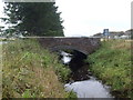
Bridge across the Monquhitter Burn
That's Millfield Farm buildings to the right.
Image: © Des Colhoun
Taken: 10 Feb 2008
0.19 miles