IMAGES TAKEN NEAR TO
TURRIFF, AB53 5TL
Introduction
This page details the photographs taken nearby to AB53 5TL by members of the Geograph project.
The Geograph project started in 2005 with the aim of publishing, organising and preserving representative images for every square kilometre of Great Britain, Ireland and the Isle of Man.

There are currently over 7.5m images from over14,400 individuals and you can help contribute to the project by visiting https://www.geograph.org.uk
Image Map
Images are licensed for reuse under creativecommons.org/licenses/by-sa/2.0
Notes
- Clicking on the map will re-center to the selected point.
- The higher the marker number, the further away the image location is from the centre of the postcode.
Image Listing (3 Images Found)
Images are licensed for reuse under creativecommons.org/licenses/by-sa/2.0
Image
Details
Distance
1

Greystone
The buildings at Greystone are surrounded by trees to provide some shelter from winter weather in this exposed situation.
Image: © Anne Burgess
Taken: 22 Jul 2014
0.01 miles
2
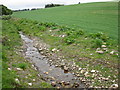
Shallow stream
The stream appears to have been newly cleared.
Image: © don cload
Taken: 23 May 2011
0.21 miles
3
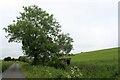
Pump House and Tree
A pump house by Muiryfold Burn, presumably supplying fresh water from springs to the nearby cottage and farm.
Image: © Andrew Wood
Taken: 29 Jun 2021
0.24 miles