IMAGES TAKEN NEAR TO
Fisherie, TURRIFF, AB53 5SW
Introduction
This page details the photographs taken nearby to AB53 5SW by members of the Geograph project.
The Geograph project started in 2005 with the aim of publishing, organising and preserving representative images for every square kilometre of Great Britain, Ireland and the Isle of Man.

There are currently over 7.5m images from over14,400 individuals and you can help contribute to the project by visiting https://www.geograph.org.uk
Image Map
Images are licensed for reuse under creativecommons.org/licenses/by-sa/2.0
Notes
- Clicking on the map will re-center to the selected point.
- The higher the marker number, the further away the image location is from the centre of the postcode.
Image Listing (4 Images Found)
Images are licensed for reuse under creativecommons.org/licenses/by-sa/2.0
Image
Details
Distance
3
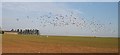
Gulls Take Flight
The flock of gulls in Image] took to the air just after I took the photograph.
Image: © Anne Burgess
Taken: 24 Oct 2007
0.18 miles
4

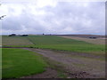
Cummerton
A flock of gulls bodes ill for the green shoots of next year's crop at Cummerton.
Image: © Anne Burgess
Taken: 24 Oct 2007
0.23 miles