IMAGES TAKEN NEAR TO
Fisherie, TURRIFF, AB53 5SL
Introduction
This page details the photographs taken nearby to AB53 5SL by members of the Geograph project.
The Geograph project started in 2005 with the aim of publishing, organising and preserving representative images for every square kilometre of Great Britain, Ireland and the Isle of Man.

There are currently over 7.5m images from over14,400 individuals and you can help contribute to the project by visiting https://www.geograph.org.uk
Image Map
Images are licensed for reuse under creativecommons.org/licenses/by-sa/2.0
Notes
- Clicking on the map will re-center to the selected point.
- The higher the marker number, the further away the image location is from the centre of the postcode.
Image Listing (6 Images Found)
Images are licensed for reuse under creativecommons.org/licenses/by-sa/2.0
Image
Details
Distance
2
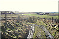
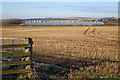
New Hedging
A new hedge is beginning to thrive at the edge of a field at Overbrae.
Image: © Anne Burgess
Taken: 5 Feb 2018
0.08 miles
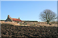
4
Hilltop view of Overbrae Farm and associated buildings
Image: © Des Colhoun
Taken: 6 Feb 2008
0.15 miles
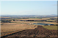
5
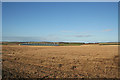
Stock sheds of Overbrae Farm beyond the stubble
Image: © Des Colhoun
Taken: 6 Feb 2008
0.20 miles
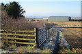
6
Chicken Sheds?
This long low building at Overbrae has the look of chicken farming, but I am happy to be corrected.
Image: © Anne Burgess
Taken: 5 Feb 2018
0.20 miles