IMAGES TAKEN NEAR TO
Crudie, TURRIFF, AB53 5QD
Introduction
This page details the photographs taken nearby to AB53 5QD by members of the Geograph project.
The Geograph project started in 2005 with the aim of publishing, organising and preserving representative images for every square kilometre of Great Britain, Ireland and the Isle of Man.

There are currently over 7.5m images from over14,400 individuals and you can help contribute to the project by visiting https://www.geograph.org.uk
Image Map
Images are licensed for reuse under creativecommons.org/licenses/by-sa/2.0
Notes
- Clicking on the map will re-center to the selected point.
- The higher the marker number, the further away the image location is from the centre of the postcode.
Image Listing (7 Images Found)
Images are licensed for reuse under creativecommons.org/licenses/by-sa/2.0
Image
Details
Distance
1
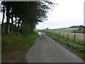
Crudie
The cottage in the trees is Pretoria Cottage.
Image: © Anne Burgess
Taken: 19 Sep 2007
0.02 miles
4
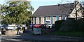
Crudie Primary School
A small country school right on the A98; there is a 20 mph speed restriction when pupils are arriving or leaving.
Image: © Anne Burgess
Taken: 19 Sep 2007
0.21 miles
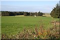
5
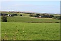
Crudie
Looking south from the main road in the village. The kirk, among the trees on the right, is in the next square, as is the farm at left, Lower Cook.
Image: © Anne Burgess
Taken: 19 Sep 2007
0.21 miles
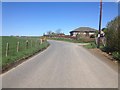
6
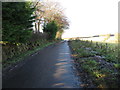
Minor road signed to Walkerhill
Looking north-westward. A private house that used to be a church is over the hedge on the left. An 1870 map has it as a Congregational Chapel.
Image: © Peter Wood
Taken: 18 Nov 2019
0.24 miles