IMAGES TAKEN NEAR TO
Lendrum Place, TURRIFF, AB53 4UE
Introduction
This page details the photographs taken nearby to Lendrum Place, AB53 4UE by members of the Geograph project.
The Geograph project started in 2005 with the aim of publishing, organising and preserving representative images for every square kilometre of Great Britain, Ireland and the Isle of Man.

There are currently over 7.5m images from over14,400 individuals and you can help contribute to the project by visiting https://www.geograph.org.uk
Image Map
Images are licensed for reuse under creativecommons.org/licenses/by-sa/2.0
Notes
- Clicking on the map will re-center to the selected point.
- The higher the marker number, the further away the image location is from the centre of the postcode.
Image Listing (2 Images Found)
Images are licensed for reuse under creativecommons.org/licenses/by-sa/2.0
Image
Details
Distance
1
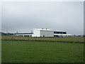
Turriff Primary School
Looking south-west to Turriff Primary School on the northern outskirts of the town.
Image: © Scott Cormie
Taken: 16 Apr 2022
0.24 miles
2
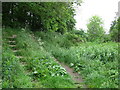
Steps from the cutting
There is a well used footpath on the old railway line. Here, the path leaves the cutting and joins a minor road that leads to the B9025.
Image: © don cload
Taken: 26 May 2011
0.24 miles