IMAGES TAKEN NEAR TO
Mill Road, TURRIFF, AB53 4SW
Introduction
This page details the photographs taken nearby to Mill Road, AB53 4SW by members of the Geograph project.
The Geograph project started in 2005 with the aim of publishing, organising and preserving representative images for every square kilometre of Great Britain, Ireland and the Isle of Man.

There are currently over 7.5m images from over14,400 individuals and you can help contribute to the project by visiting https://www.geograph.org.uk
Image Map
Images are licensed for reuse under creativecommons.org/licenses/by-sa/2.0
Notes
- Clicking on the map will re-center to the selected point.
- The higher the marker number, the further away the image location is from the centre of the postcode.
Image Listing (83 Images Found)
Images are licensed for reuse under creativecommons.org/licenses/by-sa/2.0
Image
Details
Distance
6
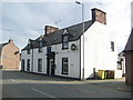
The Royal Oak, Deveron Street, Turriff
Dating from the 18th Century, but much altered. C-listed (LB42182): http://portal.historicenvironment.scot/designation/LB42182 .
Image: © Bill Harrison
Taken: 17 Sep 2016
0.05 miles
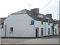
7
Castle Hill
There's not much trace of the castle from which this street presumably took its name.
Image: © Anne Burgess
Taken: 24 Oct 2007
0.05 miles
8
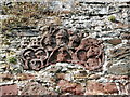
Enigmatic sculpture
Carved panel in the east end of St Congan's kirk and said to come from St Congan's Hospital (almshouse). The centre head could be King Alexander III (https://en.wikipedia.org/wiki/Alexander_III_of_Scotland ) (Buildings of Scotland guide) or Robert the Bruce (Jervise: Aberdeenshire epitaphs), who might have witnessed the foundation of the hospital in the late 13th Century.
Image: © Bill Harrison
Taken: 17 Sep 2016
0.07 miles
9
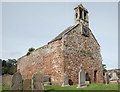
St Congan's auld kirk, Turriff
Originating in perhaps the 12th or 13th Century, the building was last used for worship in 1795 and consists of east gable-end and north and south walls. The double bellcote from 1635 is 'the finest of its type in Scotland' (Buildings of Scotland guide) and the clock was installed in 1828. A-listed (LB42163): http://portal.historicenvironment.scot/designation/LB42163 .
Image: © Bill Harrison
Taken: 17 Sep 2016
0.07 miles
10
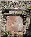
Skein monument, St Congan's kirk, Turriff
Monument to Andrew Skein, minister of the kirk from 1661-1678. The sandstone edifice is severely eroded, but 150 years' ago or so, the inscription was recorded and translated by Jervise as: Mr Andrew Skein, a man distinguished for his candour, very mighty in word and deed, the glory of the pulpit of Turriff, laid down in hope the remains of mortality, besides which he had nothing mortal, in April, 1678. This monument, such as it is, his most tender spouse, Joanna Coutts, caused to be erected as a pledge of her lasting affection. The Coutts arms are now illegible but the Skein (or Skene) arms are just legible: gules three skenes, or daggers, paleways in fess argent hiltcd and pommelled or, on the point of each a wolf's head couped of the third.
Image: © Bill Harrison
Taken: 17 Sep 2016
0.07 miles