IMAGES TAKEN NEAR TO
Wallace Lane, TURRIFF, AB53 4QX
Introduction
This page details the photographs taken nearby to Wallace Lane, AB53 4QX by members of the Geograph project.
The Geograph project started in 2005 with the aim of publishing, organising and preserving representative images for every square kilometre of Great Britain, Ireland and the Isle of Man.

There are currently over 7.5m images from over14,400 individuals and you can help contribute to the project by visiting https://www.geograph.org.uk
Image Map
Images are licensed for reuse under creativecommons.org/licenses/by-sa/2.0
Notes
- Clicking on the map will re-center to the selected point.
- The higher the marker number, the further away the image location is from the centre of the postcode.
Image Listing (84 Images Found)
Images are licensed for reuse under creativecommons.org/licenses/by-sa/2.0
Image
Details
Distance
1
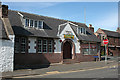
Outreach Christian Trust
According to the Outreach Christian Trust web site, OCT Turriff is no longer operating. The building is the former Turriff Drill Hall. See also Image
Image: © Anne Burgess
Taken: 22 Jul 2014
0.03 miles
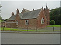
2
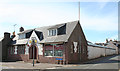
Former Drill Hall
From this angle you can see the long rear extension that housed the rifle range. See also Image
Image: © Anne Burgess
Taken: 22 Jul 2014
0.04 miles
3
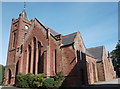
St Andrew's church, Turriff
Built 1900 in Early English style (replacing the 1844 original) and formerly the free kirk. The tower still patiently awaits the installation of the clock.
Image: © Bill Harrison
Taken: 17 Sep 2016
0.10 miles
4
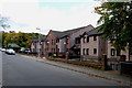
Dawson Court
A sheltered housing complex built in 1989 and run by Aberdeenshire Council.
Image: © Alex Silver
Taken: 10 Oct 2010
0.11 miles
5
St Andrew's Church Hall
The church hall on Ballmellie Road was used as an auxiliary hospital during the Great War.
Image: © John M
Taken: 4 Sep 2017
0.12 miles
6
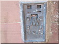
Ordnance Survey Flush Bracket 11243
This can be found on The Bank wall at 2 Belmellie Street.
For more detail see : http://www.bench-marks.org.uk/bm559
Image: © Peter Wood
Taken: 6 Oct 2012
0.12 miles
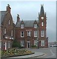
7
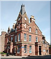
Clydesdale Bank, Turriff
Built ca. 1875 for the North of Scotland Bank in 'French style' (with gargoyle spouts) and C-listed (LB 42175): http://portal.historicenvironment.scot/designation/LB42175 .
Image: © Bill Harrison
Taken: 17 Sep 2016
0.12 miles
8
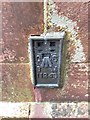
OS Flush Bracket 11243, Turriff
Flush Bracket OSBM 11243: Turriff on Clydesdale Bank
Image: © thejackrustles
Taken: 9 Aug 2019
0.12 miles
9
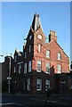
Clydesdale Bank Building
This elaborate red sandstone building at the foot of Main Street houses the Clydesdale Bank.
Image: © Anne Burgess
Taken: 24 Oct 2007
0.13 miles
10
Clydesdale Bank Building, Turriff
Head of Main Street.
Image: © JThomas
Taken: 3 Aug 2004
0.13 miles