IMAGES TAKEN NEAR TO
TURRIFF, AB53 4PE
Introduction
This page details the photographs taken nearby to AB53 4PE by members of the Geograph project.
The Geograph project started in 2005 with the aim of publishing, organising and preserving representative images for every square kilometre of Great Britain, Ireland and the Isle of Man.

There are currently over 7.5m images from over14,400 individuals and you can help contribute to the project by visiting https://www.geograph.org.uk
Image Map
Images are licensed for reuse under creativecommons.org/licenses/by-sa/2.0
Notes
- Clicking on the map will re-center to the selected point.
- The higher the marker number, the further away the image location is from the centre of the postcode.
Image Listing (5 Images Found)
Images are licensed for reuse under creativecommons.org/licenses/by-sa/2.0
Image
Details
Distance

4
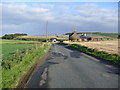
Claymires
The farm, at left of centre, is partly screened by trees, but the new houses to the right enjoy open views almost all round.
Image: © Anne Burgess
Taken: 1 May 2013
0.23 miles
5
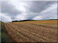
Potato field before lifting, after haulm removal
The green haulm of potatoes is removed a few weeks before the tubers are lifted.
Image: © David Hawgood
Taken: 13 Sep 2007
0.25 miles