IMAGES TAKEN NEAR TO
Forglen, TURRIFF, AB53 4JT
Introduction
This page details the photographs taken nearby to AB53 4JT by members of the Geograph project.
The Geograph project started in 2005 with the aim of publishing, organising and preserving representative images for every square kilometre of Great Britain, Ireland and the Isle of Man.

There are currently over 7.5m images from over14,400 individuals and you can help contribute to the project by visiting https://www.geograph.org.uk
Image Map
Images are licensed for reuse under creativecommons.org/licenses/by-sa/2.0
Notes
- Clicking on the map will re-center to the selected point.
- The higher the marker number, the further away the image location is from the centre of the postcode.
Image Listing (7 Images Found)
Images are licensed for reuse under creativecommons.org/licenses/by-sa/2.0
Image
Details
Distance
1
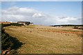
Hillhead of Mountblairy
The roadside here is lined with modern houses. The farm at the right is Westside of Forglen.
Image: © Anne Burgess
Taken: 27 Feb 2008
0.12 miles
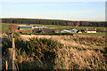
2
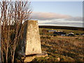
Trig point with Westside Farm in background
Image: © Douglas Barnes
Taken: 19 Jan 2008
0.20 miles
3
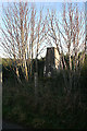
Hillhead of Mountblairy Trig Pillar
The roadside triangulation pillar near the Hillhead of Mountblairy, looking north-westwards from inside the fence.
Image: © Scott Cormie
Taken: 7 May 2022
0.20 miles
4
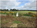
Spot the Trig Point!
It would be easy to miss this triangulation pillar if the trees had not been bare, even though it stands right on the roadside verge. Note the growth of the whins since Image] was taken.
Image: © Anne Burgess
Taken: 7 Nov 2011
0.21 miles
5
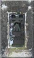
Triangulation Pillar
This is the bench mark and number of the triangulation pillar in Image
Image: © Anne Burgess
Taken: 7 Nov 2011
0.21 miles
6
Westside of Forglen
The nearer houses are in the area named on the map as Hillhead of Mountblairy, and Westside of Forglen is on the slope beyond.
Image: © Anne Burgess
Taken: 7 Nov 2011
0.23 miles
7
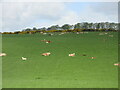
Lounging cattle
Cattle on the eastern slope of the Hill of Scotston.
Image: © Scott Cormie
Taken: 7 May 2022
0.23 miles