IMAGES TAKEN NEAR TO
Forglen, TURRIFF, AB53 4JL
Introduction
This page details the photographs taken nearby to AB53 4JL by members of the Geograph project.
The Geograph project started in 2005 with the aim of publishing, organising and preserving representative images for every square kilometre of Great Britain, Ireland and the Isle of Man.

There are currently over 7.5m images from over14,400 individuals and you can help contribute to the project by visiting https://www.geograph.org.uk
Image Map
Images are licensed for reuse under creativecommons.org/licenses/by-sa/2.0
Notes
- Clicking on the map will re-center to the selected point.
- The higher the marker number, the further away the image location is from the centre of the postcode.
Image Listing (12 Images Found)
Images are licensed for reuse under creativecommons.org/licenses/by-sa/2.0
Image
Details
Distance
2
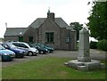
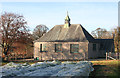
Forglen Hall
This is the community hall for Bogton and Forglen http://www.bogton.com/forglenhall
Image: © Anne Johnson
Taken: 29 Jun 2005
0.05 miles
3
A Park o' Neeps
In local parlance, a park is a field and a neep is a turnip - the kind called swedes south of the Border. These days, they're not left exposed to the elements, or more specifically to sundry pests which might attack them. The tall plants have yellow flowers and look like either self-seeded rape, or possibly just neeps that have shot.
Image: © Anne Burgess
Taken: 7 Nov 2011
0.07 miles
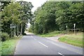
4
Forglen Hall
The hall is just beside the B9025 at its junction with the minor road to Mountblairy. This is taken from the opposite side of the B9025.
Image: © Anne Burgess
Taken: 7 Nov 2011
0.07 miles
5
Forglen Hall
A neep's eye view of the side of the hall from the adjacent field.
Image: © Anne Burgess
Taken: 7 Nov 2011
0.07 miles
6
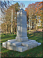
Forglen War Memorial
The memorial is in the grounds of Forglen Hall. It is of white granite, which makes it very hard to read the names of the fallen.
Image: © Anne Burgess
Taken: 7 Nov 2011
0.07 miles
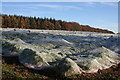
7
Inland Waves
Sometimes these covers of protective fleece over crops can look like waves on the sea.
Image: © Anne Burgess
Taken: 7 Nov 2011
0.08 miles
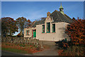
8
Scotston
The house stands at the junction of five roads.
Image: © Anne Burgess
Taken: 27 Feb 2008
0.15 miles
9
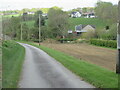
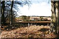
Road to Mill of Ribrae
Roadway heading to the Mill of Ribrae past a pond.
Image: © Scott Cormie
Taken: 7 May 2022
0.17 miles
10
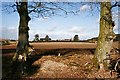
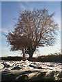
South Westside
The scars on the beeches show that it might not have been so easy to see Scotston from here - but it will look much better when they have healed over.
Image: © Anne Burgess
Taken: 27 Feb 2008
0.19 miles