IMAGES TAKEN NEAR TO
TURRIFF, AB53 4HQ
Introduction
This page details the photographs taken nearby to AB53 4HQ by members of the Geograph project.
The Geograph project started in 2005 with the aim of publishing, organising and preserving representative images for every square kilometre of Great Britain, Ireland and the Isle of Man.

There are currently over 7.5m images from over14,400 individuals and you can help contribute to the project by visiting https://www.geograph.org.uk
Image Map
Images are licensed for reuse under creativecommons.org/licenses/by-sa/2.0
Notes
- Clicking on the map will re-center to the selected point.
- The higher the marker number, the further away the image location is from the centre of the postcode.
Image Listing (2 Images Found)
Images are licensed for reuse under creativecommons.org/licenses/by-sa/2.0
Image
Details
Distance
1
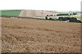
Feith Hill Farm
Looking downhill from Mid Feith Hill, the main farm is right of centre.
Image: © Anne Burgess
Taken: 19 Sep 2008
0.17 miles
2
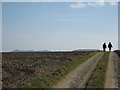
Looking South from Feith Hill towards Bennachie
Looking South from Feith Hill towards Bennachie
Image: © Elaine Cooper
Taken: 20 Apr 2008
0.18 miles