IMAGES TAKEN NEAR TO
Fortrie, TURRIFF, AB53 4HN
Introduction
This page details the photographs taken nearby to AB53 4HN by members of the Geograph project.
The Geograph project started in 2005 with the aim of publishing, organising and preserving representative images for every square kilometre of Great Britain, Ireland and the Isle of Man.

There are currently over 7.5m images from over14,400 individuals and you can help contribute to the project by visiting https://www.geograph.org.uk
Image Map
Images are licensed for reuse under creativecommons.org/licenses/by-sa/2.0
Notes
- Clicking on the map will re-center to the selected point.
- The higher the marker number, the further away the image location is from the centre of the postcode.
Image Listing (6 Images Found)
Images are licensed for reuse under creativecommons.org/licenses/by-sa/2.0
Image
Details
Distance
2
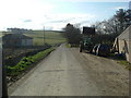
Tollo
The farm house at Tollo seems to have been extended in Victorian times from a traditional 18th century house which now forms a wing at the rear. Seen from the public road.
Image: © Anne Burgess
Taken: 9 Apr 2015
0.04 miles
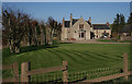
3
Tollo Farm
Tollo from the west with the Burn of Tollo on the left.
Image: © Andrew Wood
Taken: 17 Apr 2021
0.05 miles
4

Tollo Ruins
Ruined cottages by the roadside near Tollo Farm.
Image: © Andrew Wood
Taken: 17 Apr 2021
0.12 miles
5
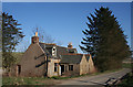
Cottages at Tollo
Evidently surplus to requirements and no longer occupied, these twin cottages stand right on the minor road at Tollo.
Image: © Anne Burgess
Taken: 9 Apr 2015
0.13 miles
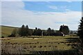
6

Tollo Track
A field access track by Tollo and a small ditch leads to the Burn of Tollo, defined by the tree line on the left, towards Fortrie.
Image: © Andrew Wood
Taken: 17 Apr 2021
0.14 miles