IMAGES TAKEN NEAR TO
TURRIFF, AB53 4HA
Introduction
This page details the photographs taken nearby to AB53 4HA by members of the Geograph project.
The Geograph project started in 2005 with the aim of publishing, organising and preserving representative images for every square kilometre of Great Britain, Ireland and the Isle of Man.

There are currently over 7.5m images from over14,400 individuals and you can help contribute to the project by visiting https://www.geograph.org.uk
Image Map
Images are licensed for reuse under creativecommons.org/licenses/by-sa/2.0
Notes
- Clicking on the map will re-center to the selected point.
- The higher the marker number, the further away the image location is from the centre of the postcode.
Image Listing (8 Images Found)
Images are licensed for reuse under creativecommons.org/licenses/by-sa/2.0
Image
Details
Distance
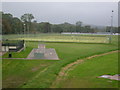
3
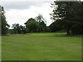
Turriff Golf Club, 12th Hole, Railway
The long twelfth hole at Turriff, looking to the green.
Image: © Scott Cormie
Taken: 4 Aug 2021
0.19 miles
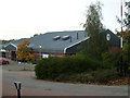
4
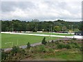
The Haughs
Home of Turriff United of the Highland League.
Image: © Richard Webb
Taken: 5 Aug 2011
0.20 miles