IMAGES TAKEN NEAR TO
Delgaty Crescent, TURRIFF, AB53 4GD
Introduction
This page details the photographs taken nearby to Delgaty Crescent, AB53 4GD by members of the Geograph project.
The Geograph project started in 2005 with the aim of publishing, organising and preserving representative images for every square kilometre of Great Britain, Ireland and the Isle of Man.

There are currently over 7.5m images from over14,400 individuals and you can help contribute to the project by visiting https://www.geograph.org.uk
Image Map
Images are licensed for reuse under creativecommons.org/licenses/by-sa/2.0
Notes
- Clicking on the map will re-center to the selected point.
- The higher the marker number, the further away the image location is from the centre of the postcode.
Image Listing (9 Images Found)
Images are licensed for reuse under creativecommons.org/licenses/by-sa/2.0
Image
Details
Distance
1
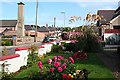
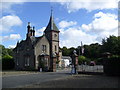
Easterfield Road
The colourful garden is that of the house on the corner of Balmellie Road and Easterfield Road. The square chimney belongs to Turriff Cottage Hospital.
Image: © Anne Burgess
Taken: 13 Sep 2007
0.15 miles
3
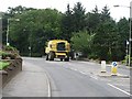
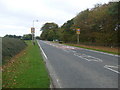
Banff Road, Turriff
Seasonal traffic on a steep hill which descends into Turriff.
Image: © Richard Webb
Taken: 4 Aug 2011
0.21 miles
4
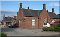
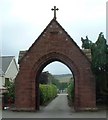
Turriff Cottage Hospital
One of a decreasing number of cottage hospitals. Like most of the older buildings in Turriff, this one is built of the local red sandstone.
Image: © Anne Burgess
Taken: 13 Sep 2007
0.22 miles
5
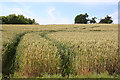
Wheat Field
Deep tramlines in a crop of wheat on the outskirts of Turriff.
Image: © Anne Burgess
Taken: 22 Jul 2014
0.22 miles
8
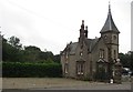
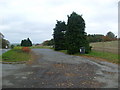
Greengate Lodge
There is a caravan dealers here and they provided some gas canisters at a good price.
Image: © Richard Webb
Taken: 4 Aug 2011
0.22 miles