IMAGES TAKEN NEAR TO
Chalmers Lane, TURRIFF, AB53 4FN
Introduction
This page details the photographs taken nearby to Chalmers Lane, AB53 4FN by members of the Geograph project.
The Geograph project started in 2005 with the aim of publishing, organising and preserving representative images for every square kilometre of Great Britain, Ireland and the Isle of Man.

There are currently over 7.5m images from over14,400 individuals and you can help contribute to the project by visiting https://www.geograph.org.uk
Image Map
Images are licensed for reuse under creativecommons.org/licenses/by-sa/2.0
Notes
- Clicking on the map will re-center to the selected point.
- The higher the marker number, the further away the image location is from the centre of the postcode.
Image Listing (31 Images Found)
Images are licensed for reuse under creativecommons.org/licenses/by-sa/2.0
Image
Details
Distance
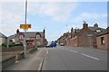
2
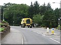
Banff Road, Turriff
Seasonal traffic on a steep hill which descends into Turriff.
Image: © Richard Webb
Taken: 4 Aug 2011
0.13 miles
3
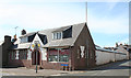
Former Drill Hall
From this angle you can see the long rear extension that housed the rifle range. See also Image
Image: © Anne Burgess
Taken: 22 Jul 2014
0.15 miles
4
Outreach Christian Trust
According to the Outreach Christian Trust web site, OCT Turriff is no longer operating. The building is the former Turriff Drill Hall. See also Image
Image: © Anne Burgess
Taken: 22 Jul 2014
0.15 miles
5
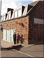
Geograph meet - sandstone buildings of Turriff
Turriff buildings are mainly sandstone; this one is in Market Street. We met at the Fife Arms across the street at 9 am for a cup of coffee. The photo shows Anne Burgess and Barbara Hawgood; see Image for a photo including David Hawgood, who took this photo.
Image: © David Hawgood
Taken: 13 Sep 2007
0.18 miles
7
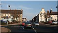
The Square
The police station is on the left and the Fife Arms Hotel on the right at the top of the square. The road ahead is the B9025 to Aberchirder (Foggieloan) and the A947 from Aberdeen to Banff has priority.
Image: © Anne Burgess
Taken: 24 Oct 2007
0.19 miles
8
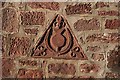
Carved Stone
This carved stone is built into the wall of a shop in Main Street.
Image: © Anne Burgess
Taken: 24 Oct 2007
0.20 miles
9
Turriff Meet
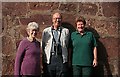
The town of Turriff is notable for a number of things including the Turra Coo (http://www.turriffanddistrict.com/index.php?topicid=4 and scroll down); a chemist's shop more famed for selling recordings of Scottish music than for aspirins, toothpaste and the like; and the red sandstone walls of the buildings in its town centre. You will find it difficult to appreciate the finer points of this example of the latter because it is partly obscured by the participants in the first Geograph meet in Scotland - from left, Barbara Hawgood, David Hawgood and Anne Burgess. (I'm not that tall - I was standing on a higher step than the others!)
Image: © A Passer-By
Taken: 13 Sep 2007
0.20 miles
10
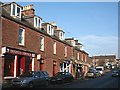
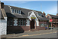
Main Street
Sandstone dominates the older buildings of Turriff, as seen in this view of Main Street. The Square is visible beyond the shops.
Image: © Anne Burgess
Taken: 24 Oct 2007
0.21 miles