IMAGES TAKEN NEAR TO
Sunnyhill Place, TURRIFF, AB53 4EU
Introduction
This page details the photographs taken nearby to Sunnyhill Place, AB53 4EU by members of the Geograph project.
The Geograph project started in 2005 with the aim of publishing, organising and preserving representative images for every square kilometre of Great Britain, Ireland and the Isle of Man.

There are currently over 7.5m images from over14,400 individuals and you can help contribute to the project by visiting https://www.geograph.org.uk
Image Map
Images are licensed for reuse under creativecommons.org/licenses/by-sa/2.0
Notes
- Clicking on the map will re-center to the selected point.
- The higher the marker number, the further away the image location is from the centre of the postcode.
Image Listing (12 Images Found)
Images are licensed for reuse under creativecommons.org/licenses/by-sa/2.0
Image
Details
Distance
1
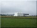
Turriff Primary School
Looking south-west to Turriff Primary School on the northern outskirts of the town.
Image: © Scott Cormie
Taken: 16 Apr 2022
0.19 miles
3
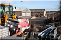
Roads Department Depot
Storage for all manner of equipment needed for road maintenance.
Image: © Anne Burgess
Taken: 1 May 2013
0.23 miles
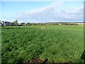
4
Gladstone Terrace3, Turriff
This is main route out of Turriff to the west and very busy with traffic (note the lack of pavement to the left).
Image: © Bill Harrison
Taken: 17 Sep 2016
0.24 miles
5
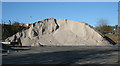
Salt Mountain
Sometimes one can't help feeling sorry for the roads department. One year they are criticised for failing to salt or grit or clear the roads, and the next they stockpile more salt and grit, only to find much of it left over, lying open to being dissolved by rain before it can be used, and are criticised for buying too much.
Image: © Anne Burgess
Taken: 1 May 2013
0.24 miles
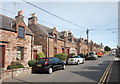
6
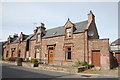
Red sandstone villas, Gladstone Terrace, Turriff
Image: © Bill Harrison
Taken: 17 Sep 2016
0.24 miles
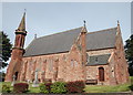
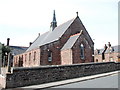
7
St Ninian and Forglen kirk, Turriff
Built 1795 to replace St Congan's kirk about 300 metres south and modified and extended over the years. The fine bellcote from 1875 pays tribute to its predecessor at St Congan's. B-listed (LB42162): http://portal.historicenvironment.scot/designation/LB42162 .
Image: © Bill Harrison
Taken: 17 Sep 2016
0.24 miles
8
St Congan's episcopal church, Turriff
Built 1862 in the popular (at the time) pseudo Early English style. The "space rocket" spirelet resembles that at Old Meldrum: http://www.geograph.org.uk/photo/4989356 . C-listed (LB42181): http://portal.historicenvironment.scot/designation/LB42181 .
Image: © Bill Harrison
Taken: 17 Sep 2016
0.24 miles
9
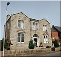
Former(?) masonic lodge, Gladstone Terrace, Turriff
1924 on the date-stone: unusually built in Aberdeen granite rather than Turriff sandstone. At least part of the building is now occupied by the Citizen's Advice Bureau.
Image: © Bill Harrison
Taken: 17 Sep 2016
0.24 miles
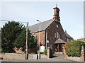
10
Church hall, Gladstone Terrace, Turriff
Image: © Bill Harrison
Taken: 17 Sep 2016
0.25 miles