IMAGES TAKEN NEAR TO
Schoolhill, TURRIFF, AB53 4DX
Introduction
This page details the photographs taken nearby to Schoolhill, AB53 4DX by members of the Geograph project.
The Geograph project started in 2005 with the aim of publishing, organising and preserving representative images for every square kilometre of Great Britain, Ireland and the Isle of Man.

There are currently over 7.5m images from over14,400 individuals and you can help contribute to the project by visiting https://www.geograph.org.uk
Image Map
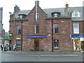
Images are licensed for reuse under creativecommons.org/licenses/by-sa/2.0
Notes
- Clicking on the map will re-center to the selected point.
- The higher the marker number, the further away the image location is from the centre of the postcode.
Image Listing (137 Images Found)
Images are licensed for reuse under creativecommons.org/licenses/by-sa/2.0
Image
Details
Distance
1
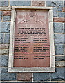
War memorial, Turriff
An unusual and poignant WWI memorial on School Hill, paying tribute to former members of the Turriff Boys' Brigade.
Image: © Bill Harrison
Taken: 17 Sep 2016
0.01 miles
2
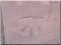
Ordnance Survey Cut Mark
This can be found on the wall of the British Legion in High Street.
For more detail see : http://www.bench-marks.org.uk/bm45917
Image: © Peter Wood
Taken: 6 Oct 2012
0.02 miles
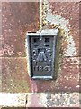
3
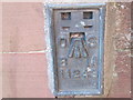
Ordnance Survey Flush Bracket 11243
This can be found on The Bank wall at 2 Belmellie Street.
For more detail see : http://www.bench-marks.org.uk/bm559
Image: © Peter Wood
Taken: 6 Oct 2012
0.02 miles
4
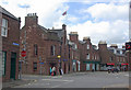
Balmellie Street, Turriff
Looking into High Street in the centre of this small town; the building straight ahead is the Royal British Legion.
Image: © Stephen McKay
Taken: 28 May 2011
0.02 miles
5
OS Flush Bracket 11243, Turriff
Flush Bracket OSBM 11243: Turriff on Clydesdale Bank
Image: © thejackrustles
Taken: 9 Aug 2019
0.02 miles
6
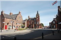
Turriff town centre
The High Street (foreground) curves to the left to become Main Street. Straight on for Balmellie Street and right for School Hill. The Union flag flies over the British Legion club as observed by the Turra Coo statue to the left.
Image: © Bill Harrison
Taken: 17 Sep 2016
0.03 miles
7
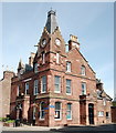
Clydesdale Bank, Turriff
Built ca. 1875 for the North of Scotland Bank in 'French style' (with gargoyle spouts) and C-listed (LB 42175): http://portal.historicenvironment.scot/designation/LB42175 .
Image: © Bill Harrison
Taken: 17 Sep 2016
0.03 miles
8
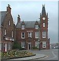
Clydesdale Bank Building, Turriff
Head of Main Street.
Image: © JThomas
Taken: 3 Aug 2004
0.03 miles
10
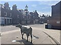
The Turra Coo
The Turra Coo (Doric for "the Turriff Cow") was a white Ayrshire-Shorthorn cross dairy cow which lived near the Aberdeenshire town of Turriff in north-east Scotland in the early twentieth century. The cow became famous following a dispute between her owner, supported by local people, against the government over taxes and compulsory national insurance.
Image: © Ralph Greig
Taken: 10 Jun 2023
0.04 miles