IMAGES TAKEN NEAR TO
INSCH, AB52 6YY
Introduction
This page details the photographs taken nearby to AB52 6YY by members of the Geograph project.
The Geograph project started in 2005 with the aim of publishing, organising and preserving representative images for every square kilometre of Great Britain, Ireland and the Isle of Man.

There are currently over 7.5m images from over14,400 individuals and you can help contribute to the project by visiting https://www.geograph.org.uk
Image Map
Images are licensed for reuse under creativecommons.org/licenses/by-sa/2.0
Notes
- Clicking on the map will re-center to the selected point.
- The higher the marker number, the further away the image location is from the centre of the postcode.
Image Listing (1 Images Found)
Images are licensed for reuse under creativecommons.org/licenses/by-sa/2.0
Image
Details
Distance
1
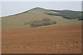
Little Flinder and Hill of Flinder
Recently ploughed and sown red earth extends almost uninterrupted from this viewpoint to the Hill of Flinder (293 metres). The farm at Little Flinder is surrounded by sheltering trees. Above the forest plantation, to the right, the summit of the Hill of Christ's Kirk is just visible on the skyline.
Image: © Anne Burgess
Taken: 25 Apr 2009
0.02 miles