IMAGES TAKEN NEAR TO
INSCH, AB52 6YX
Introduction
This page details the photographs taken nearby to AB52 6YX by members of the Geograph project.
The Geograph project started in 2005 with the aim of publishing, organising and preserving representative images for every square kilometre of Great Britain, Ireland and the Isle of Man.

There are currently over 7.5m images from over14,400 individuals and you can help contribute to the project by visiting https://www.geograph.org.uk
Image Map
Images are licensed for reuse under creativecommons.org/licenses/by-sa/2.0
Notes
- Clicking on the map will re-center to the selected point.
- The higher the marker number, the further away the image location is from the centre of the postcode.
Image Listing (3 Images Found)
Images are licensed for reuse under creativecommons.org/licenses/by-sa/2.0
Image
Details
Distance
1
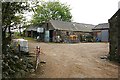
Mains of Duncanstone
The farm buildings are fairly typical, mainly traditional stone-built barns and byres, with a more modern one sporting corrugated iron doors. My great-grandmother's brother was a farm servant here in 1871.
Image: © Anne Burgess
Taken: 25 Apr 2009
0.04 miles
2
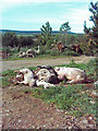
Death at Lazyfold farm
This looks like a group of dead pigs awaiting pick up by the knackery. Pig farmers in particular prefer the knackery lorry not to come right up the road to where the pigs are kept as this is a way that disease can be spread.
Image: © Andrew Stuart
Taken: 31 May 2007
0.17 miles
3
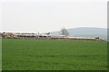
Lazyfold
The long line of low buildings aren't exactly photogenic. From the sound and smell emanating from it, it isn't hard to deduce that the barn on the left houses a herd of pigs, though I did not go close enough to see them. The buildings straddle the grid line; those at the right are in square. The hill on the skyline is Knock Saul.
Image: © Anne Burgess
Taken: 25 Apr 2009
0.25 miles