IMAGES TAKEN NEAR TO
Culsalmond, INSCH, AB52 6UP
Introduction
This page details the photographs taken nearby to AB52 6UP by members of the Geograph project.
The Geograph project started in 2005 with the aim of publishing, organising and preserving representative images for every square kilometre of Great Britain, Ireland and the Isle of Man.

There are currently over 7.5m images from over14,400 individuals and you can help contribute to the project by visiting https://www.geograph.org.uk
Image Map
Images are licensed for reuse under creativecommons.org/licenses/by-sa/2.0
Notes
- Clicking on the map will re-center to the selected point.
- The higher the marker number, the further away the image location is from the centre of the postcode.
Image Listing (3 Images Found)
Images are licensed for reuse under creativecommons.org/licenses/by-sa/2.0
Image
Details
Distance
1
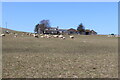
Goukswell Farm
Sheep grazing before Goukswell Farm on the lower slopes of Tillymorgan Hill. Gouk in Scots means cuckoo.
Image: © Andrew Wood
Taken: 17 Apr 2021
0.05 miles
2
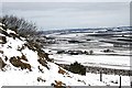
Goukswell from the Hill of Tillymorgan
A view from part way up the hill towards the extensive farming country to the north and east.
Image: © Anne Burgess
Taken: 26 Mar 2008
0.07 miles
3
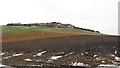
Tillymorgan Hill
The remains of the slate quarries can be seen above the arable land. The foreground field was being ploughed at the time.
Image: © Richard Webb
Taken: 21 Dec 2011
0.11 miles