IMAGES TAKEN NEAR TO
Culsalmond, INSCH, AB52 6UL
Introduction
This page details the photographs taken nearby to AB52 6UL by members of the Geograph project.
The Geograph project started in 2005 with the aim of publishing, organising and preserving representative images for every square kilometre of Great Britain, Ireland and the Isle of Man.

There are currently over 7.5m images from over14,400 individuals and you can help contribute to the project by visiting https://www.geograph.org.uk
Image Map
Images are licensed for reuse under creativecommons.org/licenses/by-sa/2.0
Notes
- Clicking on the map will re-center to the selected point.
- The higher the marker number, the further away the image location is from the centre of the postcode.
Image Listing (14 Images Found)
Images are licensed for reuse under creativecommons.org/licenses/by-sa/2.0
Image
Details
Distance
1
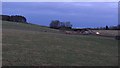
A920, Kirkton of Culsalmond
Looking over fields at dusk (mid afternoon) towards oncoming lights on a nearby road.
I like the name, although given the 40% pay cut I have just had, I would settle for Culrussell.
Image: © Richard Webb
Taken: 21 Dec 2011
0.12 miles
2
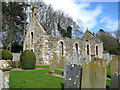
Kirkton of Culsalmond church
The old church of Culsalmond was built in 1791 and abandoned in 1938. The fine bell tower dates from the 17th century.
In the kirkyard there is an old mort house and a watch house designed to protect the newly dead from the body snatchers who supplied the anatomy schools in Aberdeen.
Image: © Martyn Gorman
Taken: 7 Apr 2007
0.13 miles
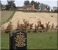
3
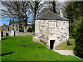
Kirkton of Culsalmond kirkyard
The building in the background is the old manse. The building in the foreground was built in the early 1800s to deter the activities of grave robbers who stole bodies for sale to the anatomy schools in Aberdeen. The upper part of the building is a watch house where the men guarding new graves could find shelter. Below, there is an immensely strong vault or morthouse in which fresh bodies were stored under lock and key until too corrupt to be of interest to the anatomists. They were then buried in the normal way.
Image: © Martyn Gorman
Taken: 7 Apr 2007
0.13 miles
4
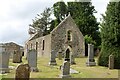
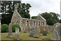
The Auld Kirk
The old kirk of Culsalmond with its kirkyard seen from the east.
Image: © Andrew Wood
Taken: 21 Jul 2022
0.13 miles
5
Kirkton of Culsalmond old kirk
Built ca. 1791 and abandoned in 1937, when the parish church was relocated to the former Free Church a few hundred metres to the south-west. The ruin, which is now fenced off for safety reasons, is A-listed, largely for its ornate 17th Century bellcote. The bell is said to have migrated to Keithhall and Kinkell Kirk: http://www.geograph.org.uk/photo/4978187 .
Image: © Bill Harrison
Taken: 30 Aug 2015
0.13 miles
6
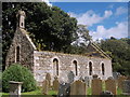
Old Culsalmond Kirkyard
The old kirkyard at Culsalmond from the south-east,
Image: © Andrew Wood
Taken: 21 Jul 2022
0.14 miles
7
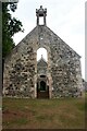
Kirk Gable and Bell Tower
The west gable of the old kirk of Culsalmond and its empty bell tower. Built in 1791 this church was abandoned in 1937, the west end lies in one grid square and the east in another.
Image: © Andrew Wood
Taken: 21 Jul 2022
0.14 miles
8
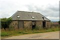
Kirkton Stable
A derelict old stable block at Kirkton Farm.
Image: © Andrew Wood
Taken: 21 Jul 2022
0.15 miles
9
At the Bottom of Culsalmond Brae
Buildings at the bottom of Culsalmond Brae, apparently an old schoolhouse and school. A small crossroad is at the right the A920 crossing two minor roads.
Image: © Andrew Wood
Taken: 21 Jul 2022
0.15 miles
10
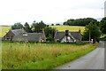
Kirkton Farm
Seen from Culsalmond cemetery.
Image: © Stanley Howe
Taken: 29 Mar 2012
0.16 miles