IMAGES TAKEN NEAR TO
Leslie, INSCH, AB52 6PF
Introduction
This page details the photographs taken nearby to AB52 6PF by members of the Geograph project.
The Geograph project started in 2005 with the aim of publishing, organising and preserving representative images for every square kilometre of Great Britain, Ireland and the Isle of Man.

There are currently over 7.5m images from over14,400 individuals and you can help contribute to the project by visiting https://www.geograph.org.uk
Image Map
Images are licensed for reuse under creativecommons.org/licenses/by-sa/2.0
Notes
- Clicking on the map will re-center to the selected point.
- The higher the marker number, the further away the image location is from the centre of the postcode.
Image Listing (3 Images Found)
Images are licensed for reuse under creativecommons.org/licenses/by-sa/2.0
Image
Details
Distance
1
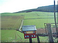
"House" Letter Box
The hand made letter box is for either East Drumgowan or Drumgowan farms, maybe even both. The letter box is on the side of the Clatt - Leslie road.
Image: © Andrew Stuart
Taken: 28 Apr 2007
0.15 miles
2
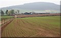
Johnston
The track on the left is not marked on the current maps. The foreground field is in square, but the farm buildings at Johnston are in the next square. The hill on the skyline is Knock Saul.
Image: © Anne Burgess
Taken: 25 Apr 2009
0.23 miles
3
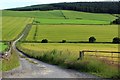
Drumgowan Road
The combined access road to Drumgowan and East Drumgowan Farms.
Image: © Andrew Wood
Taken: 12 Jul 2020
0.24 miles