IMAGES TAKEN NEAR TO
Leslie, INSCH, AB52 6PE
Introduction
This page details the photographs taken nearby to AB52 6PE by members of the Geograph project.
The Geograph project started in 2005 with the aim of publishing, organising and preserving representative images for every square kilometre of Great Britain, Ireland and the Isle of Man.

There are currently over 7.5m images from over14,400 individuals and you can help contribute to the project by visiting https://www.geograph.org.uk
Image Map
Images are licensed for reuse under creativecommons.org/licenses/by-sa/2.0
Notes
- Clicking on the map will re-center to the selected point.
- The higher the marker number, the further away the image location is from the centre of the postcode.
Image Listing (4 Images Found)
Images are licensed for reuse under creativecommons.org/licenses/by-sa/2.0
Image
Details
Distance
1
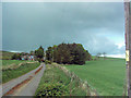
New Leslie
Taken just before a good thundery shower, looking up the farm road from a gateway into the adjacent field.
Image: © Andrew Stuart
Taken: 20 May 2007
0.03 miles
2
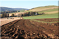
Looking towards New Leslie
The farm buildings are in the next square, but the cultivated land is mostly in this square.
Image: © Anne Burgess
Taken: 3 Nov 2015
0.09 miles
3
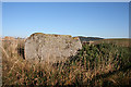
Braehead Recumbent Stone Circle (2)
This is the recumbent, the only surviving stone of this circle, with a very even and horizontal upper surface. See http://canmore.org.uk/site/17643/braehead for further details. Image]
Image: © Anne Burgess
Taken: 3 Nov 2015
0.25 miles
4
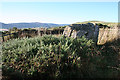
Braehead Recumbent Stone Circle (3)
Although it is partly obscured by whins, you can see that this recumbent is still upright, and that its upper surface is pretty horizontal. See http://canmore.org.uk/site/17643/braehead for further details. Image]
Image: © Anne Burgess
Taken: 3 Nov 2015
0.25 miles