IMAGES TAKEN NEAR TO
Leslie, INSCH, AB52 6PA
Introduction
This page details the photographs taken nearby to AB52 6PA by members of the Geograph project.
The Geograph project started in 2005 with the aim of publishing, organising and preserving representative images for every square kilometre of Great Britain, Ireland and the Isle of Man.

There are currently over 7.5m images from over14,400 individuals and you can help contribute to the project by visiting https://www.geograph.org.uk
Image Map
Images are licensed for reuse under creativecommons.org/licenses/by-sa/2.0
Notes
- Clicking on the map will re-center to the selected point.
- The higher the marker number, the further away the image location is from the centre of the postcode.
Image Listing (2 Images Found)
Images are licensed for reuse under creativecommons.org/licenses/by-sa/2.0
Image
Details
Distance
1
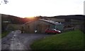
Country Frames Gallery, Little Chapelton
Off the road from Leslie to Bogs.
Image: © Stanley Howe
Taken: 6 Dec 2014
0.20 miles
2
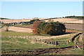
Looking towards Little Chapelton
The farm buildings are in the next square.
Image: © Anne Burgess
Taken: 3 Nov 2015
0.24 miles