IMAGES TAKEN NEAR TO
Mortimer's Way, INSCH, AB52 6AE
Introduction
This page details the photographs taken nearby to Mortimer's Way, AB52 6AE by members of the Geograph project.
The Geograph project started in 2005 with the aim of publishing, organising and preserving representative images for every square kilometre of Great Britain, Ireland and the Isle of Man.

There are currently over 7.5m images from over14,400 individuals and you can help contribute to the project by visiting https://www.geograph.org.uk
Image Map
Images are licensed for reuse under creativecommons.org/licenses/by-sa/2.0
Notes
- Clicking on the map will re-center to the selected point.
- The higher the marker number, the further away the image location is from the centre of the postcode.
Image Listing (7 Images Found)
Images are licensed for reuse under creativecommons.org/licenses/by-sa/2.0
Image
Details
Distance
1
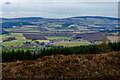
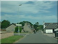
Village of Auchleven
View from the Black hill
Image: © Ralph Greig
Taken: 23 Feb 2023
0.06 miles
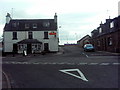
3
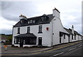
The New Moon, Auchleven
The pub is pretty modest about its identity in the centre of the Aberdeenshire village of Auchleven (also known as Premnay).
Image: © Bill Harrison
Taken: 15 Sep 2018
0.18 miles
4
Old Shell Service Station Auchleven (Premnay)
Image: © Gilbert Scott
Taken: 31 Jul 2007
0.19 miles
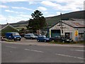
6
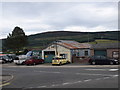
Village garage
The petrol pumps are long gone but there seems to be good business with repairs...
Image: © Bill Harrison
Taken: 15 Sep 2018
0.19 miles
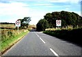
7
Premnay Crossroads
Straight on to Leslie, Right to Insch and Left to Keig. While this village is called Auchleven, locally it is known as Premnay and some signs now have both names on them.
Image: © Andrew Stuart
Taken: 7 Jun 2007
0.21 miles